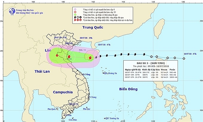
Typhoon Son Tinh to make landfall Wednesday night
 |
| Typhoon Son Tinh’s projected path.- Photo nchmf.gov.vn |
At 7am on Wednesday, the typhoon was about 390km to the east of provinces from Thai Binh to Ha Tinh, and was moving west at 25-30km per hour.
Torrential rains with up to 350mm are forecast in northern delta provinces down to localities from Thanh Hóa to Quang Binh.
The provinces of Hoa Bình, Son La, Lai Chau, Dien Bien, Lao Cai, Yen Bai, Ha Giang, Tuyen Quang, Quang Ninh, Thanh Hoa, Nghe An, Ha Tinh and Quang Binh have been put on high alert of landslides and flash floods, the national forecasting centre said.
Lowland and urban areas in Hai Duong, Ha Nam, Nam Dinh, Ninh Binh, Thai Binh, Hoa Binh, Hanoi and Vinh Phuc, and from Thanh Hoa to Quang Binh, are likely to be inundated.
Urgent meeting
In response to the situation, the Central Steering Committee for Natural Disaster Prevention and Control on Tuesday organised an urgent meeting with relevant agencies to direct preparations for the typhoon.
The meeting was chaired by Tran Quang Hoai, head of the Vietnam Disaster Management Authority.
Speaking at the meeting, Hoài ordered border soldiers and rescue forces to ready for emergencies.
One of the most important tasks was instructing offshore vessels to seek shelter from danger areas, he said.
Hoài told the authority’s Dyke Management Department to check the sea defences to ensure residents’ safety. He added that the department should have materials on hand to repair the dykes if any incidents occurred.
Localities were also instructed to check reservoir levels in the wake of torrential rains, he said.
In a related movement, the Khe Bo Hydro-Power Plant in the central province of Nghe An’s Tuong Duong District opened its floodgates early on Wednesday to reduce water levels in its reservoir following torrential rains over the past couple of days.
What the stars mean:
★ Poor ★ ★ Promising ★★★ Good ★★★★ Very good ★★★★★ Exceptional
 Tag:
Tag:
Related Contents
Latest News
More News
- Congratulations from VFF Central Committee's int’l partners to 14th National Party Congress (January 25, 2026 | 09:46)
- List of newly-elected members of 14th Political Bureau announced (January 23, 2026 | 16:27)
- 14th Party Central Committee unanimously elects To Lam as General Secretary (January 23, 2026 | 16:22)
- List of members of 14th Party Central Committee announced (January 23, 2026 | 09:12)
- Highlights of fourth working day of 14th National Party Congress (January 23, 2026 | 09:06)
- Press provides timely, accurate coverage of 14th National Party Congress (January 22, 2026 | 09:49)
- Press release on second working day of 14th National Party Congress (January 22, 2026 | 09:19)
- Minister sets out key directions to promote intrinsic strength of Vietnamese culture (January 22, 2026 | 09:16)
- 14th National Party Congress: Renewed momentum for OVs to contribute to homeland (January 21, 2026 | 09:49)
- Party Congress building momentum for a new era of national growth (January 20, 2026 | 15:00)


 Mobile Version