Extreme weather forecast for start of 2019
 |
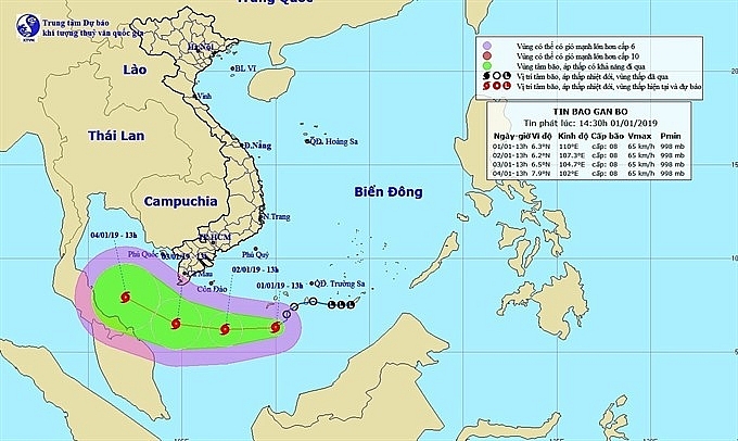
| The direction of typhoon PABUK. |
Downpours are expected in the entire central region while extreme weather events such as tornadoes and hailstorms could hit the Central Highlands and southern region.
Average temperatures in different regions in January will be higher than those of previous years, by between 0.5 to 1 degree Celsius.
Total rainfall in the north will also experience an upward trend, mostly in the first half of the month, while the central region will see rainfall 20 to 50 per cent higher than previous years.
Off-season rains will appear in the Central Highlands and southern region on the first ten days of the year.
First storm
The first storm of 2019, internationally called Typhoon PABUK, formed in southwest of the Spratly Islands yesterday.
At 13.00 on Tuesday, the storm’s eye was seen 450km southeast of Côn Đảo Island. Wind speeds at the eye reached up to 75 km per hour. The storm is predicted to move west – southwest at 10 to 15km per hour and be 280km southeast of Côn Đảo Island.
With the effects of the storm and extreme cold spells, strong winds are forecast to hit the western area of the East Sea (South China Sea), as well as seas of provinces from Quảng Ngãi to Bình Thuận and from Bà Rịa – Vũng Tàu to Cà Mau.
Preparing for the upcoming storm, from 12.00 yesterday, Cà Mau Province People’s Committee prohibited boats and ships from operating in the provincial sea.
Authorities of coastal provinces from Quảng Ngãi to Cà Mau and Kiên Giang urged related agencies including rescue forces and media to track the storm’s movement, monitor ships and mobilise search and rescue teams in case of emergency.
What the stars mean:
★ Poor ★ ★ Promising ★★★ Good ★★★★ Very good ★★★★★ Exceptional
 Tag:
Tag:
Related Contents
Latest News
More News
- Nestlé Vietnam's Lunar New Year campaign reframes how Tet is counted (January 28, 2026 | 11:40)
- Tet event in Japan celebrates success of 14th National Party Congress (January 25, 2026 | 10:04)
- 14th National Party Congress wraps up with success (January 25, 2026 | 09:49)
- Congratulations from VFF Central Committee's int’l partners to 14th National Party Congress (January 25, 2026 | 09:46)
- List of newly-elected members of 14th Political Bureau announced (January 23, 2026 | 16:27)
- 14th Party Central Committee unanimously elects To Lam as General Secretary (January 23, 2026 | 16:22)
- List of members of 14th Party Central Committee announced (January 23, 2026 | 09:12)
- Highlights of fourth working day of 14th National Party Congress (January 23, 2026 | 09:06)
- Press provides timely, accurate coverage of 14th National Party Congress (January 22, 2026 | 09:49)
- Press release on second working day of 14th National Party Congress (January 22, 2026 | 09:19)


 Mobile Version