Sleeping beauty of Van Phong Bay
 |
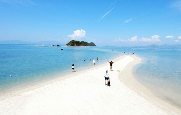
| Parting of the sea: The road under the sea level in Diep Son island. - Photo vivudulich.top |
From the city of Nha Trang, we travel 80km north, until we reach Van Phong on a beautiful, sunny day.
The bay is known as an ensemble of many small gulfs and multi-shaped islands.
The most recognisable island is Bip Island, also named Diep Son (Mountain of Butterfly Island), with 83 households with limited access to electricity and fresh water.
The island consists a group of three smaller islands and the journey to explore the island starts from Van Gia Town. After an hour on sea, dreamy Diep Son Island began to form on the horizon.
The most staggering thing about the island is the unique and stunning road a metre under sea level, which is 700m long and connects the middle island with the Mountain of Butterfly Island.
“Strolling on this road brings about extreme excitement, a thrill and a bit of scare when we walk among the infinite ocean. I really like to watch the fish swimming on the two sides and wave to boats passing by,” said my travel partner Nguyen Thanh Thuy.
We spent a short time on Diep Son Island before heading to Ong Island (The Whale Island). Different from other tourism islands in the fact it is uninhabited, we only found a resort called Whale Island Resort, which provides all services on this island.
Environmental protection is a taken seriously on the island, showed by the signboard my friend read saying, “no fishing or bird hunting are allowed on the island”.
I think the island is created for sea lovers, who would like to explore unspoilt, desolated and pristine destinations, or who wish to temporarily escape the suffocating urban life, as well as newlyweds on honeymoon.
A couple from New Zealand who were vacationing there told me the island was nine or 10 stars in terms of style and location.
Staying several days on the island, we hired a boat to reach Dam Mon Peninsula. With a total area of 128 squ.km, including 20 islands and a primival forest, Dam Mon Beach is silent, calm and fresh. Since it is covered and protected by Hon Gom and Hon Lon peninsulas, big waves rarely hit the beach.
Across the peninsula, we headed to Son Dung (or Xuan Dung) Hamlet. A small one with only ten households, the hamlet is home to the Dang Ha ethnic minority, whose ancestors are Malaysians or Indonesians who were shipwrecked on the island in the 18th or 19th century.
The hamlet has no roads, as people travel across the sand. As for the beach, I have never seen anywhere so picturesque, probably as it was devoid of visitors.
What is odd here is you can find fresh water from the beach’s sand. Taking a few steps from the sea, digging sand close to the salt water, fresh water will rise in the small hole. Not far from the beach is Lach plain, a breathtaking site of coral and stone.
Northwest of Van Phong Bay is Hon Gom Peninsula, a natural complex of small mountain ranges and sand dunes. Hon Gomlooks like outreached hands treasuring the diamond of Hon Lon (Big Island). The island covers and protects Van Phong Bay so ships can shelter from big storms.
We finished our trip by boating to Twins Cape at Hon Gom. Bearing the name because of two stones pointing to the East Sea, we couldn’t take our eyes from the imposing view of the bay and the stone masterpieces.
To me, Van Phong Bay should be known as the Mother of islands instead of Sleeping Beauty, as the beauty of this place is far from hidden.
What the stars mean:
★ Poor ★ ★ Promising ★★★ Good ★★★★ Very good ★★★★★ Exceptional
Latest News
More News
- Manila becomes a new check-in destination for Vietnamese youth (December 11, 2025 | 18:07)
- Vietjet launches mega year-end ticket promotion (December 10, 2025 | 11:33)
- Dalat leads Vietnam’s 2025 search trends (December 09, 2025 | 13:44)
- Vietnam welcomes record wave of international visitors (December 09, 2025 | 13:43)
- Vietjet launches daily Manila flights to celebrate year-end festive peak season (December 05, 2025 | 13:47)
- The destinations powering Vietnam’s festive season travel demand (December 04, 2025 | 18:33)
- Vietnam named among the world’s most exciting winter destinations (December 04, 2025 | 15:10)
- Phu Tho emerges as northern Vietnam’s new tourism hub (December 01, 2025 | 17:00)
- Vietjet completes Airbus A320/A321 updates ahead of deadline (December 01, 2025 | 09:49)
- Vietjet resumes Con Dao flights from early December (November 28, 2025 | 15:24)


 Mobile Version