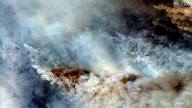
Australian bushfire cloud visible in Chile and Argentina
 |
| This Jan 4, 2020, satellite natural colour image released by Maxar Technologies shows smoke from wildfires east of Orbost, Australia. (HO/Satellite image ©2020 Maxar Technologies/AFP) |
In the early hours "the effect was seen in the sun through red tones. This effect was produced by a cloud of smoke that comes from the fires," Chile meteorology chief, Patricio Urra, told AFP.
The cloud has risen to 6,000m above sea level and there is no meteorological reason for it to fall back to Earth, said Urra.
It poses no threat to Chileans.
The Argentine Meteorological Service published satellite images of the cloud saying it had been "transported by frontal systems that move from west to east".
However, it added that all that would be visible was "a sun that's a little redder".
Regional meteorological company Metsul said the cloud could even reach Rio Grande del Sur state in Brazil.
Catastrophic bushfires have turned swathes of Australia into smouldering, blackened hellscapes and destroyed an area about the size of the island of Ireland, according to official figures.
They have left 25 people dead and authorities warn the disaster still has weeks or months to run.
What the stars mean:
★ Poor ★ ★ Promising ★★★ Good ★★★★ Very good ★★★★★ Exceptional
Related Contents
Latest News
More News
- Vietnam ranks among top 50 happiest countries in 2026 (March 20, 2026 | 09:00)
- International media spotlight Vietnam’s National Assembly election (March 16, 2026 | 09:41)
- Citi report finds global trade transformed by tariffs and AI (February 25, 2026 | 10:49)
- ASEAN unveils digital outlook, AI readiness research (February 11, 2026 | 11:52)
- Vietnam and Laos step up urban and infrastructure cooperation (February 04, 2026 | 16:04)
- Space Summit 2026 opens in Singapore amid alignment calls (February 02, 2026 | 17:00)
- PM inspects APEC 2027 project progress in An Giang province (January 29, 2026 | 09:00)
- Philippines plans higher rice imports to stabilise supply (January 28, 2026 | 11:11)
- France supports Vietnam’s growing role in international arena: French Ambassador (January 25, 2026 | 10:11)
- Foreign leaders extend congratulations to Party General Secretary To Lam (January 25, 2026 | 10:01)

 Tag:
Tag:


 Mobile Version