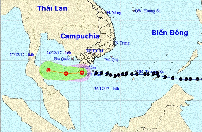
Typhoon Tembin weakens to tropical low pressure
 |
| Typhoon Tembin weakened to tropical depression. The depression will continue to move west in the next 12-24 hours. - Photo from the National Hydrometeorological Forecast Centre |
At 4am on Tuesday, the eye of the tropical depression was some 8.5 degrees north, 105.2 degrees east, right along the coast of Bạc Liêu and Cà Mau provinces. The strongest winds in the area near the eye of the tropical low pressure levelled at 6-7 (40-60km/hour) and shock level was 9.
The tropical depression is forecast to keep moving west for the next 12 hours, with wind speed of 15-20km/hour.
In the next 12 to 24 hours, the tropical depression will continue to move west to the Gulf of Thailand. The strongest wind in the centre of the low pressure area will drop to below level 6 (below 40km/hour).
On Tuesday, the sea areas from Bà Rịa-Vũng Tàu to Cà Mau and on the mainland of Bạc Liêu and Cà Mau provinces have experienced gusts of wind at level 6.
In addition, due to the influence of the tropical low pressure circulation combined with cold air over the sea from Quảng Ngãi to Bình Thuận (including Phú Quý Island) there will be strong winds of level 6, gusts of wind of level 8 and risk level of disaster at level 3.
Moderate rainfall is forecast in the south and heavy rains will last for 2-3 days in the south central and mid-central provinces. From Tuesday night, moderate and heavy rains are likely to extend to the north central and north regions.
What the stars mean:
★ Poor ★ ★ Promising ★★★ Good ★★★★ Very good ★★★★★ Exceptional
Latest News
More News
- Congratulations from VFF Central Committee's int’l partners to 14th National Party Congress (January 25, 2026 | 09:46)
- List of newly-elected members of 14th Political Bureau announced (January 23, 2026 | 16:27)
- 14th Party Central Committee unanimously elects To Lam as General Secretary (January 23, 2026 | 16:22)
- List of members of 14th Party Central Committee announced (January 23, 2026 | 09:12)
- Highlights of fourth working day of 14th National Party Congress (January 23, 2026 | 09:06)
- Press provides timely, accurate coverage of 14th National Party Congress (January 22, 2026 | 09:49)
- Press release on second working day of 14th National Party Congress (January 22, 2026 | 09:19)
- Minister sets out key directions to promote intrinsic strength of Vietnamese culture (January 22, 2026 | 09:16)
- 14th National Party Congress: Renewed momentum for OVs to contribute to homeland (January 21, 2026 | 09:49)
- Party Congress building momentum for a new era of national growth (January 20, 2026 | 15:00)


 Mobile Version