Typhoon Rai changes direction, gradually weakens
 |
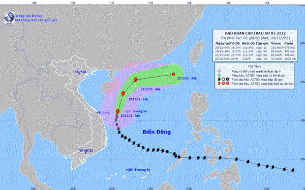
| Typhoon Rai's projected trajectory (Photo: National Centre for Hydro-meteorological Forecasting) |
Hanoi – Typhoon Rai, the ninth storm to hit Vietnam in the East Sea, was about 200km to the east-northeast of Ly Son island of the central coastal province of Quang Ngai at 4am on December 20, with gust near the eye of the storm reaching 200 km per hour, according to the National Centre for Hydro-meteorological Forecasting.
The typhoon is forecast to change direction to move north-northeast at a speed of 15-20km per hour on early December 21.
By 4am December 22, Rai will move east-northeast at 10-15km per hour, and then weaken into a tropical depression and late a low pressure zone.
As the typhoon approached, strong wind and torrential rains were expected in the central region, with high-level warnings issued for flooding.
As of December 19 evening, 172 families residing in high-risk areas in Quang Ngai’s Ly Son district had evacuated to safer places in an effort to mitigate losses caused by Typhoon Rai, announced the People’s Committee of the district.
In addition, 719 out of 725 fishing vessels of Ly Son fishermen had taken shelter and local authorities were able to contact owners of the remainders, said Chairwoman of the Committee Pham Thi Huong.
All aquaculture facilities had been safely moved to land, she added.
What the stars mean:
★ Poor ★ ★ Promising ★★★ Good ★★★★ Very good ★★★★★ Exceptional
 Tag:
Tag:
Related Contents
Latest News
More News
- Congratulations from VFF Central Committee's int’l partners to 14th National Party Congress (January 25, 2026 | 09:46)
- List of newly-elected members of 14th Political Bureau announced (January 23, 2026 | 16:27)
- 14th Party Central Committee unanimously elects To Lam as General Secretary (January 23, 2026 | 16:22)
- List of members of 14th Party Central Committee announced (January 23, 2026 | 09:12)
- Highlights of fourth working day of 14th National Party Congress (January 23, 2026 | 09:06)
- Press provides timely, accurate coverage of 14th National Party Congress (January 22, 2026 | 09:49)
- Press release on second working day of 14th National Party Congress (January 22, 2026 | 09:19)
- Minister sets out key directions to promote intrinsic strength of Vietnamese culture (January 22, 2026 | 09:16)
- 14th National Party Congress: Renewed momentum for OVs to contribute to homeland (January 21, 2026 | 09:49)
- Party Congress building momentum for a new era of national growth (January 20, 2026 | 15:00)


 Mobile Version