NASA satellite finds crashed Indian Moon lander
 |
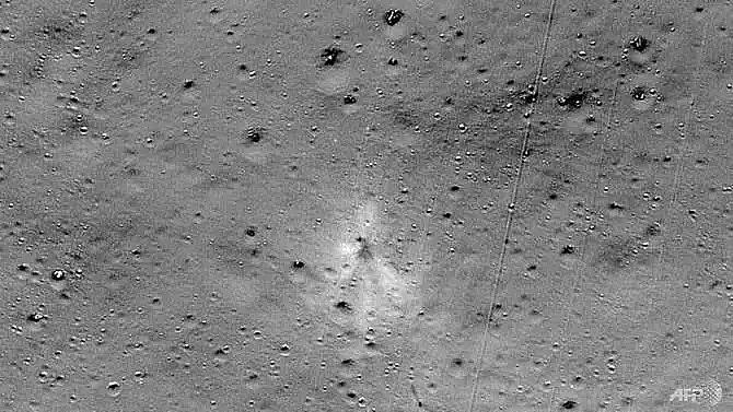
| This handout image released by NASA, and taken by the Lunar Reconnaissance Orbiter Camera team shows the Vikram Lander impact point. (Handout/NASA/AFP) |
NASA released an image taken by its Lunar Reconnaissance Orbiter (LRO) that showed the site of the spacecraft's impact (Sep 6 in India and Sep 7 in the US) and associated debris field, with parts scattered over almost two dozen locations spanning several kilometres.
In a statement, NASA said it released a mosaic image of the site on Sep 26, inviting the public to search it for signs of the lander.
It added that a person named Shanmuga Subramanian contacted the LRO project with a positive identification of debris - with the first piece found about 750 meters northwest of the main crash site.
Blasting off in July, emerging Asian giant India had hoped with its Chandrayaan-2 ("Moon Vehicle 2") mission to become just the fourth country after the United States, Russia and regional rival China to make a successful Moon landing, and the first on the lunar south pole.
The main spacecraft, which remains in orbit around the Moon, dropped the unmanned lander Vikram for a descent that would take five days, but the probe went silent just 2.1 kilometres above the surface.
Days after the failed landing, the Indian Space Research Organisation said it had located the lander, but hadn't been able to establish communication.
What the stars mean:
★ Poor ★ ★ Promising ★★★ Good ★★★★ Very good ★★★★★ Exceptional
 Tag:
Tag:
Related Contents
Latest News
More News
- Russian President congratulates Vietnamese Party leader during phone talks (January 25, 2026 | 09:58)
- Worldwide congratulations underscore confidence in Vietnam’s 14th Party Congress (January 23, 2026 | 09:02)
- Political parties, organisations, int’l friends send congratulations to 14th National Party Congress (January 22, 2026 | 09:33)
- 14th National Party Congress: Japanese media highlight Vietnam’s growth targets (January 21, 2026 | 09:46)
- 14th National Party Congress: Driving force for Vietnam to continue renewal, innovation, breakthroughs (January 21, 2026 | 09:42)
- Vietnam remains spiritual support for progressive forces: Colombian party leader (January 21, 2026 | 08:00)
- Int'l media provides large coverage of 14th National Party Congress's first working day (January 20, 2026 | 09:09)
- Vietnamese firms win top honours at ASEAN Digital Awards (January 16, 2026 | 16:45)
- ASEAN Digital Ministers' Meeting opens in Hanoi (January 15, 2026 | 15:33)
- ASEAN economies move up the global chip value chain (December 09, 2025 | 13:32)


 Mobile Version