Vietnam on high alert for earthquakes, tsunamis
 |
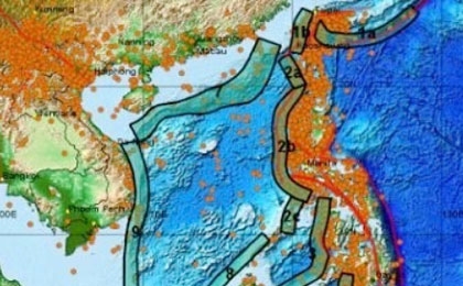
| Map of tsunami areas in the East Sea region |
>>Blast at Japan nuke plant; 10,000 missing after quake
Le Huy Minh, Director of the Earthquake and Tsunami Warning Centre under the Vietnam Institute of Geophysics, said, due to geographical characteristics, the Vietnamese coastal areas are likely to be greatly affected by any tsunami in the East Sea area.
He added that, the waters to the north of the Philippines can pose the most danger to Vietnam because it would take around two hours for a tsunami to hit the central coastal areas of Vietnam from this area. In such a case, the coastal area in Danang City will be the hardest-hit.
Other areas, including Quang Ninh Province and Haiphong City, may be less affected. These risks are forecast based on the institute’s 25 scenarios of tsunamis on the East Sea and Vietnamese beaches.
According to Minh, an earthquake that reached 4.7 on the Richter scale occurred off Vung Tau-Phan Thiet coast on March 6. However, it had almost no effect on the coast.
Cao Duc Phat, Minister of Agriculture and Rural Development and Head of the Central Steering Board for Storm Prevention and Control, said the Government has issued regulations on earthquake and tsunami preparedness, but many localities are still not ready for any such event.
The People’s Committee of Danang City has approved the installation of 10 early tsunami warning stations. The stations, the first of their kind in Vietnam, are expected to help warn people in Danang of tsunamis from the East Sea 30 minutes in advance.
What the stars mean:
★ Poor ★ ★ Promising ★★★ Good ★★★★ Very good ★★★★★ Exceptional
Latest News
More News
- Foreign leaders extend congratulations to Party General Secretary To Lam (January 25, 2026 | 10:01)
- 14th National Party Congress wraps up with success (January 25, 2026 | 09:49)
- Congratulations from VFF Central Committee's int’l partners to 14th National Party Congress (January 25, 2026 | 09:46)
- 14th Party Central Committee unanimously elects To Lam as General Secretary (January 23, 2026 | 16:22)
- Worldwide congratulations underscore confidence in Vietnam’s 14th Party Congress (January 23, 2026 | 09:02)
- Political parties, organisations, int’l friends send congratulations to 14th National Party Congress (January 22, 2026 | 09:33)
- Press release on second working day of 14th National Party Congress (January 22, 2026 | 09:19)
- 14th National Party Congress: Japanese media highlight Vietnam’s growth targets (January 21, 2026 | 09:46)
- 14th National Party Congress: Driving force for Vietnam to continue renewal, innovation, breakthroughs (January 21, 2026 | 09:42)
- Vietnam remains spiritual support for progressive forces: Colombian party leader (January 21, 2026 | 08:00)


 Mobile Version