Calamity forecast in Ho Chi Minh City
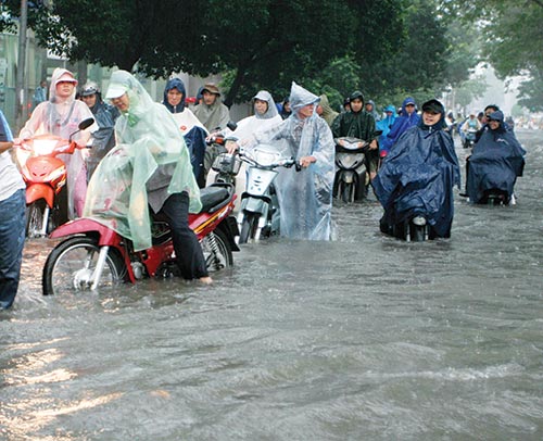
City residents face major risks caused by rising waters Photo: Le Toan
According to the Southern Hydrometeorology Agency, towards the end of this year, the flood-tide in the 2,000-square-kilometre city may reach the highest it has been in 62 years, peaking at over 1.7 metres, higher than the 1.68 metres recorded last year.
This means that more areas will be flooded, bringing traffic to a standstill, and creating significant difficulties throughout the city.
A recent survey by the Asian Development Bank on Ho Chi Minh City’s adaptation to climate change states that it would be one of the ten cities throughout the world worst affected by climate change, because much of it is almost level with the sea’s surface.
Some 40-45 per cent of the city’s land is zero to five metres higher than sea level, while 15-20 per cent is only one to two metres above sea level.
The survey stated that natural calamities annually cost the city an average of $12.6 million. The figure is expected to rise in the future due to bigger tropical storms in southern Vietnam.
From 2006-2050, the city will lose $6.7-22.1 billion due to frequent flooding, while the city’s GDP will lose $48.3 billion.
In 2007, nearly 1.7 million people lived with flooding, and the figure is expected to rise to 12.9 million by 2050.
By 2050, almost all types of roads will be hit by extreme flooding. Also susceptible are all planned monorails (33km), railways (187km) and metro lines (36km). Furthermore, all ports and waterways will also face the same fate.
“Notably however, the city’s Tan Son Nhat international airport and nearby Dong Nai province’s Long Thanh international airport may be safe from flooding thanks to their elevation above sea level. However, they will likely be isolated and inaccessible,” said the survey.
Sections of the city’s expressways will also be flooded, including the Saigon-Long Thanh-Dau Giay (22.7km), Ho Chi Minh City-Trung Luong-Can Tho (41km) and Ho Chi Minh City-Moc Bai (5.6km).
Many power plants like Phu My and Hiep Phuoc and other power stations will also be inundated by 2050 as they are located in areas prone to flooding.
Meanwhile, the city’s southern water provision sector is also at risk, including all current waste water treatment facilities and drainage systems, which will cause major pollution if no preventative measures are taken.
Almost all industrial parks and complexes in the city are expected to be flooded even within the best case scenario of the city’s control plans.
Regarding the agricultural sector, nearly 60 per cent of arable land will be inundated, leaving a large part of the city’s land heavily salinated.
“By 2050, polluted water will flow into agricultural land, creating a big threat to agricultural production and people’s health,” noted the survey.
According to the Vietnam Climate Adaptation Partnership, led by Dutch consultancy firm Grontmij and aimed at securing a climate adaptation strategy in the city’s urban planning, over the past number of years the city has frequently been hit by flooding due to an increase in heavy rains and a lack of reservoirs. This rise in flood waters has been matched by a worrying rise in temperatures.
In this densely-populated delta city, where the economy and population are booming, risks for the inhabitants are steadily rising, due to rising sea levels and higher river discharges.
What the stars mean:
★ Poor ★ ★ Promising ★★★ Good ★★★★ Very good ★★★★★ Exceptional
Latest News


More News
- Going green to save a bundle (June 08, 2015 | 10:00)
- Green buildings: the rising trend (June 02, 2015 | 09:41)
- Green buildings – key to sustainable urban development in Vietnam (May 18, 2015 | 17:00)
- Feed-in tariffs continue to haunt green energy prospects (December 15, 2014 | 10:47)
- Building material types intrinsic to green ratings (December 09, 2014 | 11:56)
- Turning an eco- smart dream into reality (December 09, 2014 | 11:55)
- Green products enjoy a growing presence at Vietbuild Hanoi 2014 (December 01, 2014 | 10:06)
- Country profits from green building (November 24, 2014 | 11:02)
- Firms flout enviroment laws (November 17, 2014 | 10:48)
- Energy efficient sticks and carrots (November 10, 2014 | 15:30)


 Mobile Version