Advanced tactics required to keep Ho Chi Minh City afloat
 |
| Advanced tactics required to keep Ho Chi Minh City afloat |
A report released by international consultants McKinsey & Company in April revealed that Ho Chi Minh City’s extreme flood risk could increase by 5-10 times by 2050, leading to the economic loss of billions of US dollars.
According to the group, despite contributing about a quarter of Vietnam’s GDP, Ho Chi Minh City is burdened with potential of increasing flooding. While the city is struggling with such risks affecting approximately 23 per cent of the area, the subsequent urbanisation process is also increasing pressure of land subsidence and sea level rise.
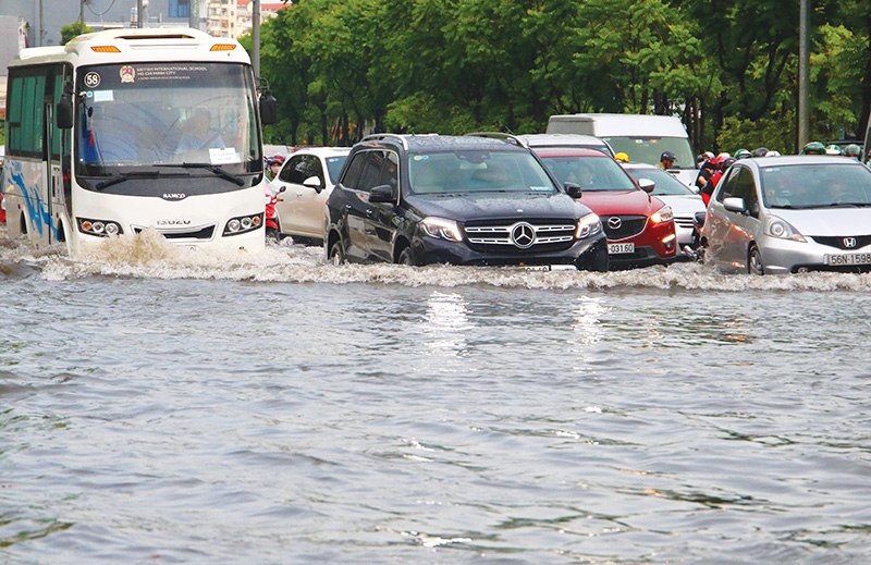
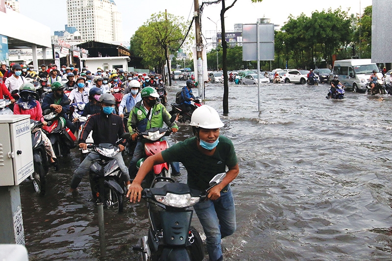
In Ho Chi Minh City, the image of roads suddenly turning into rivers has become familiar in recent years. In the rainy season and during high tide, many routes are often flooded, making people’s lives harder and damaging businesses.
In District 8, floods have become a regular occurrence. Along the Lo Gum channel, there are always baskets of sandbags ready to help prevent water from invading people’s homes or companies.
Talking with VIR, 60-year-old Nguyen Van Phu said that he has spent more than 30 years living in the area and his life has become familiar with the flow of unwanted water. “We raise our house’s ground every year and have built a small dyke outside the door but this is not enough. We still have to get a pump in order to pump water out of the house on the serious days,” Phu said.
The damages from flooding can be devastating for business households on front-facing streets. Huynh Thi Thao, the owner of a construction material outlet in District 8, said that she lost VND50 million ($2,200) after one flood when she could not remove materials in time. Her children have also been forced off from school due to the flood.
In Ho Chi Minh City, serious flooding takes place in many areas, such as districts 7, 2, 4, and in Binh Thanh, where roads become rivers after rains and also in afternoons when the tide tends to rise Thao Dien commune in District 2 and Nguyen Huu Canh – a street commonly known as consisting of more well-off people – also suffer from deep flooding, caused by the unsynchronised infrastructure system.
Strong impacts
The McKinsey & Company report stated that economic growth leading to land use changes can increase exposure to flooding. The central parts of the city, typically safer due to natural elevation, are “hollowing out” as the growth of commercial and high-end residential real estate pushes people towards more affordable regions on lower ground.
In District 7, some main roads are raised each year using funding from a flood toll collected from users. But even when government and developers pay, investing to adapt can bring unexpected costs. In 2018, Huynh Tan Phat street, a major thoroughfare, was raised 20-30cm at a cost of about $20 million, covered by developers and the government.
The purpose was to avoid disruption and damage, but unintended consequences came along with it. Now that the road is higher, residents of adjoining homes need to cope with water pouring in, or otherwise pay to upgrade their residences, which can cost up to $2,000 for a 90-square-metre house.
Property consultant Hoang Manh Ha suggested that buyers must carefully consider locations in which they want to buy assets, especially in terms of infrastructure and drainage system. “If you are careless about this factor you will face many difficulties when living in those assets, and you will also face difficulties if you want to transfer it,” Ha said.
Some higher locations and better infrastructure system districts such as districts 2 and 9 have been attracting interest from home buyers.
Another reason for flooding is the overlapping between plans in recent years. Ho Chi Minh City has implemented two main master plans – the first a drainage system until 2020 via Decision No.752/QD-TTg from 2001 and a second on improving the irrigation system approved in 2008’s Decision No.1547/QD-TTg.
The plans overlap in their functions and despite implementation, no real tangible results can be gleaned from them.
 |
| City residents have seen an increase in rainy season struggles due to flooded streets |
Further delays
The municipal administration has spent nearly VND26 trillion ($1.11 billion) worth of public and private funds on flood control projects over the past five years, according to the Center for Technical Infrastructure Management under Ho Chi Minh Ctiy Department of Construction.
According to Vu Van Diep, director of the Ho Chi Minh City Infrastructure Management Centre, at least 25 out of 36 heavily-flooded sites have been handled during the five-year period, noting the number of such sites has dropped by 104 since 2008.
Up to now, routes previously considered as flood hot spots in the city include Cay Go roundabout, Le Hong Phong, Ky Dong, Tran Quang Khai, Tran Khac Chan, Hai Ba Trung, Phan Dinh Phung, Phan Xich Long, Binh Thoi, the Cho Lon bus station area, No Trang Long, Kinh Duong Vuong, Le Lai, and Nguyen Bieu.
Projects to improve drainage and the sewage system have unfortunately seen long delays.One involved a revamp of Nguyen Huu Canh street in Binh Thanh district where city authorities have spent around VND500 billion ($21.7 million) but flooding is still occurring.
Meanwhile, an initiative to invest VND10 trillion ($430 million) to control tidal flooding and climate change is set to miss operation schedule in October due to difficulties in site clearance. Around a dozen households near the Muong Chuoi floodgate in the outlying district of Nha Be have also yet to hand over their land to local authorities.
According to Nguyen Tam Tien, general director of project constructor Trung Nam Group, 78 per cent of work load has been completed so far.
This project is expected to benefit around 6.5 million city dwellers in a 570-square-kilometre stretch of land on the right bank of the Saigon River and in downtown Ho Chi Minh City. It will also help regulate water levels in city canals, improve local water drainage, and beautify the landscape of nearby areas.
McKinsey & Company said that despite being burdened by flooding, Ho Chi Minh City still has time to adapt and the city has many options to avert impacts because it is still relatively early in its development journey. As less than half of the city’s major infrastructure needed for 2050 exists today, many adaptation options could be highly effective.
Three key steps mapped out by the group’s report outlined better planning to reduce exposure and risk, investing in adaptation through hardening and resilience, and financial mobilisation to mitigate impacts on lower-income populations.
| Three flood scenarios from McKinsey & Company Today: We estimate that 23 per cent of the city could flood, and a range of existing assets would be taken offline; infrastructure damage may total $200-300 million. Knock-on effects would be significant, and we estimate could total a further $100-400 million. Real estate damage may total $1.5 billion. 2050: A flood with the same probability in 30 years’ time would likely do three times the physical damage and deliver 20 times the knock-on effects. We estimate that 36 per cent of the city could become flooded. In addition, many of the 200 new infrastructure assets are planned to be built in flooded areas. As a result, the damage bill would grow, totaling $500 million to $1 billion. Increased economic reliance on assets would amplify knock-on effects, leading to an estimated $1.5-8.5 billion in losses. An additional $8.5 billion in real estate damages could occur. A 180cm sea-level rise scenario: A percentage point of probability flood in this scenario may bring three times the extent of flood area. About 66 per cent of the city would be underwater, driven by a large western area that suddenly passes an elevation threshold. Under this scenario, damage is critical and widespread, totaling an estimated $3.8-7.3 billion. Much of the city’s functionality may be shut down, with knock-on effects costing $6.4-45.1 billion. Real estate damage could total $18 billion. |
Ngo Viet Nam Son - Architect
 |
Flooding is a scientific issue therefore it must be dealt by scientific solutions which can ensure that the flooding is able to be handled and will not happen again.
In Ho Chi Minh City, some anti-flood projects have been implemented. All projects are costly but inefficient, and roads are often flooded. This shows that the city’s urban management has not been effective.
I think the city should have a new approach. Specifically, to increase the investment but also to make sure that there will be no floods. Or at least, if floods remain, they must be under control at some specific points only, and solutions must be always ready to rescue those areas in emergency circumstances.
The solution must be synchronised in all aspects, from increasing the flow of drainage system, building dykes, and replacing drainage pipelines. Right now it seems that only one solution is implemented – that is making roads higher. This is not an effective method because the water is transferred from here to there only. If Vietnam is not able to do this, we can call on support from foreign experts and attract investment capital from the private sector.
Luu Duc Cuong Phd. - Director, Institute for Environmental Planning and Urban-Rural Infrastructure Ministry of Construction
 |
Flooding has been a problem in Ho Chi Minh City for years and it has become more serious in recent years. One of the main reasons for this heavy flood was the lack of synchronised investment in urban drainage and sewerage systems to cope with the constantly increasing growth of urbanisation.
In addition, the city’s current anti-flooding activities have only temporarily improved the flooding situation in the central area. Eight out of 12 areas including the suburban areas do not have detailed drainage planning yet.
There have been a lot of studies and proposals for flood control solutions for Ho Chi Minh City, especially solutions such as building embankments, upgrading bridges and roads. However all of those solutions are not much effective. Therefore, we need an additional urban management solution to support traditional solutions to deal with this issue.
Do Tan Long - Deputy director, Ho Chi Minh City Infrastructure Management Centre
 |
The serious flooding in Ho Chi Minh City caused by the current drainage system can meet capacity for two million people, but the population is five times higher. Meanwhile, the sewage system is degraded and can only meet 70 per cent of the required capacity. In order to gradually solve the situation, Ho Chi Minh City has in the past implemented two main master plans. But in addition, the city needs to improve its drainage network connecting from small to large alleys as well as increasing the construction of tidal sluices to prevent water invading into the inner-city.
Vo Kim Cuong - Former deputy chief architect, Ho Chi Minh City
 |
The main reason for the current flooding in Ho Chi Minh City is that the two master plans have not harmonised with each other. The first plan, carried out many years ago, had invested in improving the drainage system but did not cover rising tides. The second plan involves a dyke system with investment capital of VND10 trillion ($434.78 million) to decrease the water level in canals and break through the water flow from the inner-city out.
I hope that the second plan helps to save the whole city from flooding when it is completed later this year.
What the stars mean:
★ Poor ★ ★ Promising ★★★ Good ★★★★ Very good ★★★★★ Exceptional
 Tag:
Tag:
Related Contents
Latest News
More News
- NAB Innovation Centre underscores Vietnam’s appeal for tech investment (January 30, 2026 | 11:16)
- Vietnam moves towards market-based fuel management with E10 rollout (January 30, 2026 | 11:10)
- Vietnam startup funding enters a period of capital reset (January 30, 2026 | 11:06)
- Vietnam strengthens public debt management with World Bank and IMF (January 30, 2026 | 11:00)
- PM inspects APEC 2027 project progress in An Giang province (January 29, 2026 | 09:00)
- Vietnam among the world’s top 15 trading nations (January 28, 2026 | 17:12)
- Vietnam accelerates preparations for arbitration centre linked to new financial hub (January 28, 2026 | 17:09)
- Vietnam's IPO market on recovery trajectory (January 28, 2026 | 17:04)
- Digital economy takes centre stage in Vietnam’s new growth model (January 28, 2026 | 11:43)
- EU Council president to visit Vietnam amid partnership upgrade (January 28, 2026 | 11:00)


 Mobile Version